Point cloud and geospatial data management.
About the product
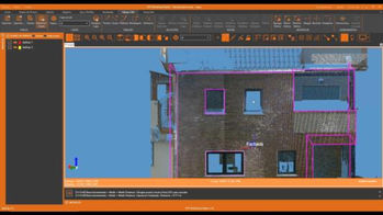
Standalone application that allows to display, edit and analyze point clouds captured by fixed or mobile scanners, LiDAR technology or generated by photogrammetry applications.
Points can have attributes of color, intensity, time, category and returns and be represented based on these properties. You can apply offsets, rotations, or transformations to clouds, as well as register them using control points.
You can also generate and analyze surfaces and grids, calculate profiles and volumes and draw with a simple CAD on the point cloud, etc. It offers multiple options for importing and exporting formats such as LandXML, IFC, DWG, 3D PDF, etc. The projects can be published in the cloud and be inspected by a web viewer.
SOLUTIONS
Explore how our applications are used in your sector or industry.

PUBLIC ADMINISTRATION
Our range of products allows us to develop or check a wide variety of Topography and Civil Engineering projects and include everything from field applications to powerful office applications.
QUARRIES AND MINING
We offer solutions to meet the needs of all types of quarry and mine operations, both open-pit and underground.


CIVIL ENGINEERING
Solutions that facilitate the development of road projects, railways, tunnels, dams, power lines, pipes and all types of civil works.
BUILDING AND URBANISATION
In addition to tools for terrain modelling, our software facilitates the subdivision of parcels, road design for urbanisations, integration with BIM and much more.


DRONES AND PHOTOGRAMMETRY
Our range of products covers everything from generating geomatics products from photographs captured by drones to photogrammetric restitution.
WATER AND ENERGY
Solutions to simplify the work of technical offices of public or private companies supplying water, sanitation, gas, electricity, telecommunications, etc.


ENVIRONMENT
The land analysis functions of our software allow you to map slopes, orientations and visibilityas well as importing and exporting data from Geographic Information Systems The source data can be surveys, mapping, elevation models provided by Geographic Information Systems or even point clouds.
GIS
Our products letyou use the geographic information of web services and open data, and generate results that can be easily integrated into corporate GIS.


BIM
APLITOP actively participates with buildingSMART International to implement IFC Alignment and IFC Road formats, which will be used in the exchange of open data of land, roads, railways, tunnels, etc.

.png)


